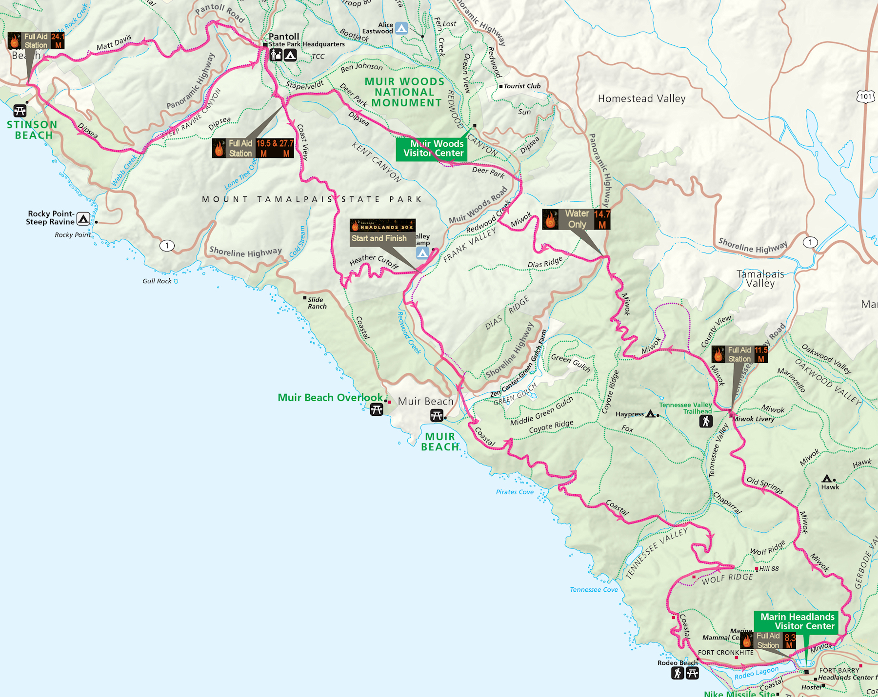
Course Map
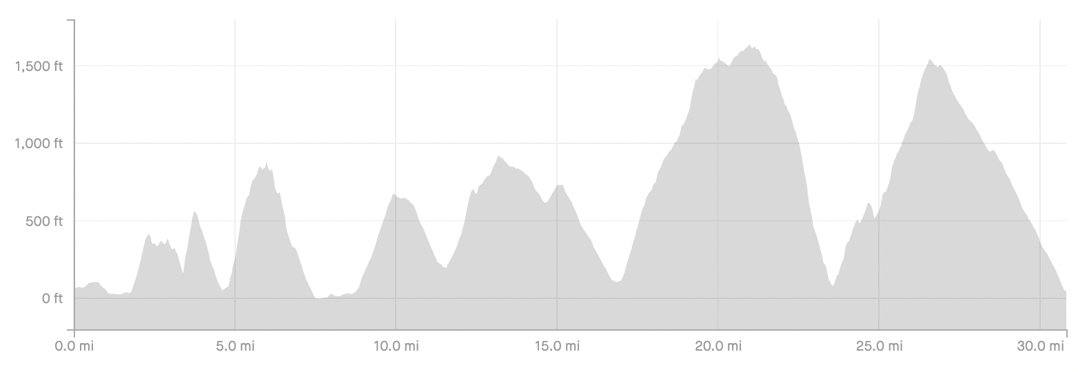
Elevation Chart
Course GPX File
Download the course GPX file
See the GPX file in Google Maps
Aid Stations with Cutoffs
| Aid Station | Distance overall (in miles) | Distance to next aid (in miles) | Elev gain to next aid (in feet) | Elev loss to next aid (in feet) | cutoff |
| Santos Meadow (Start) | 0.0 | 8.3 | 1,690 | 1,710 | n/a |
| Rodeo Beach | 8.3 | 3.2 | 620 | 430 | None |
| Tennessee Valley - East | 11.5 | 3.3 | 940 | 500 | 4:00 hrs (11:30am) |
| Highway 1* | 14.8 | 4.7 | 1,340 | 640 | 5:00 hrs (12:30pm) |
| Cardiac Hill #1 | 19.5 | 4.6 | 730 | 2,020 | 6:30 hrs (2:00pm) |
| Stinson Beach | 24.1 | 3.6 | 1,590 | 300 | 8:00 hrs (3:30pm) |
| Cardiac Hill #2 | 27.7 | 3.8 | 80 | 1,380 | 9:15 hrs (4:45pm) |
| Santos Meadow (Finish) | 31.5 | 10:00 hrs (5:30pm) |
* Water Only at Highway 1 Aid Station.
Turn by Turn Course Description
Distances Measured with Garmin 310XT, subject to variation between other runners and forms of measurement. Hundredths of a mile provided only to give relative distance between way points.
(This description is also available as a printable Google Doc)
0.00 M - Santos Meadow Start, between two vertical poles, southeast side of horse corral next to Muir Beach Volunteer Fire Department Event Facility. Run east across Santos Meadow, bearing right toward the entry gate.
0.15 M - Exit Santos Meadow at the entry gate, and turn right onto Muir Woods Road, cross the road and run on the left side, and continue west on road for 0.2 M.
0.35 M – Turn left off Muir Woods Road at trail sign post, toward Redwood Creek Trail, and after several switchbacks turn right on Redwood Creek Trail, heading west toward Muir Beach and Highway 1.
1.05 M – End of Redwood Creek Trail, turn left onto Muir Woods Road heading west, stay on left side of road as Muir Woods Road ends and intersects Highway 1 (Shoreline Highway), cross Highway 1 bearing left and run on right side of Highway 1 South heading towards Muir Beach.
1.3 M – Turn right on Pacific Way (paved) toward Muir Beach, the Pelican Inn on the corner. Almost immediately turn left onto Muir Beach Trail towards Middle Green Gulch and Coastal Trails.
1.5 M – Bear right, cross a small bridge over a small creek, and continue straight past the gate to Middle Green Gulch Trail on the left.
1.8 M – Turn left (uphill) on Coastal Trail (fire road) towards Pirates Cove, Tennessee Valley, and Rodeo Beach.
2.3 M – Stay straight and continue on Coastal Trail (single track trail) towards Pirates Cove. Coastal Fire Road bends left.
3.4 M – Following descent to Pirate Cove turn left (uphill) continuing on Coastal Trail.
3.8 M - Leave single track trail, head straight, then downhill, merging onto Coastal Trail (Fire Road). Coastal Fire Road comes in from the left. Descend to Tennessee Valley.
4.45 M – Turn left onto Tennessee Valley Trail (Fire Road).
4.5 M – Turn right off Tennessee Valley Trail (Fire Road) onto Coastal Trail (single track trail).
4.6 M – Cross Tennessee Valley Trail (single track), and continue on Coastal Trail, toward Wolf Ridge and Rodeo Beach.
5.8 M – Top of Wolf Ridge, turn right on a paved path toward Rodeo Beach.
5.9 M – Turn right off pavement onto single track trail (route leaves Coastal Trail), and follow along the ridgeline past foundations from fortifications.
6.2 M – Follow trail downhill to the right off the ridgeline.
6.25 M – Trail becomes the width of the fire road, with fortification foundations above to the left.
6.35 M – Turn right onto Coastal Trail (route rejoins Coastal Trail).
6.42 M – Turn left down stairs (Coastal Trail).
6.50 M – Turn right onto pavement (Coastal Trail).
6.52 M – Turn left on trail (Coastal Trail).
6.60 M - Stone Steps (now mostly wood) with metal railings.
6.78 M – Left onto pavement (Coastal Trail).
6.80 M – Right on pavement (Coastal Trail).
7.20 M – Right off pavement onto Coastal Trail (Hikers Route).
7.44 M – Right onto pavement, and proceed through/around the gate, and continue straight to Rodeo Beach parking lot and bathrooms.
7.6 M – Cross to the right (south) side of Bunker Road, and continue east along a dirt path.
8.25 M – Bear left on trail, and cross over Bunker Road, past the corner of Building T1111, and bear right through/around the gate and onto Miwok Trail (fire road).
8.3 M – Rodeo Beach Aid Station
8.6 M – Stay left on Miwok Trail (fire road).
8.75 M – Continue straight on Miwok Trail (fire road), where Bobcat Trail turns right.
9.9 M – Continue straight on Miwok Trail (fire road).
10.2 M – Turn left on Old Springs Trail toward Tennessee Valley.
11.4 M – At Miwok Stables turn left onto Miwok Trail (fire road), and head towards Tennessee Valley parking lot.
11.5 M – Tennessee Valley Aid Station
11.55 M – Turn right on Tennessee Valley Road, and then almost immediately left on Miwok Trail (single track), toward Coyote Ridge and Highway 1.
12.5 M - Turn left staying on Miwok Trail (fire road) at the intersection with County View Road (fire road).
12.5 M – Almost immediately head straight onto Miwok Cutoff Trail. Miwok Trail (fire road) bears right.
12.9 M – Cross small single track trail and turn left on Miwok Trail (fire road).
13.2 M – Bear right on Miwok Trail (fire road). Coyote Ridge Trail goes straight and uphill.
14.7 M – Highway 1 Aid Station
14.7 M – Leaving Highway 1 Aid Station, stay left on the single track trail, keeping wooden posts on your right.
14.8 M – Cross Highway 1, and continue on Miwok trail (single track) toward Dias Ridge.
15.1 M – Turn left on Dias Ridge Trail.
15.25 M - Turn right on Miwok Trail (single track). Dias Ridge Trail continues straight.
16.9 M – Turn right on Redwood Creek Trail at “T” intersection (Miwok Trail ends).
17.0 M – Cross small bridge, don’t take horse trail into and back out of creek.
17.2 M – Cross Muir Woods Road, go through/around the gate, and head up Deer Park Fire Road.
17.7 M – Intersection with Dipsea Trail. Deer Park Fire Road bends left and uphill. Transition onto Dipsea Trail (on right). Over the next 2 miles the Deer Park Fire Road and Dipsea Trail cross each other multiple times. Stay on the Dipsea Trail (single track) where available.
19.2 M – Bear slightly left on Dipsea Trail (Ben Johnson Trail goes right).
19.25 M – Turn left on Deer Park Fire Road.
19.3 M – Turn right and uphill on Dipsea Trail (single track).
19.4 M – Bear slightly left up Dipsea Trail (Stapeveldt Trail turns right).
19.5 M – Cardiac Hill (Dipsea Trail) Aid Station
19.5 M – Turn right on Coastal Fire Road, uphill toward Pantoll Ranger Station.
19.6 M – After 100 yds turn right onto Old Mine Trail toward Pantoll Ranger Station.
20.1 M – End of Old Mine Trail, turn right on paved road, toward Pantoll Ranger Station.
20.15 M – Veer left across parking lot towards small fight of steps up to Panoramic Highway (step by blue Ridge Trail sign).
20.20 M – Cross Panoramic Highway, and bear left uphill on Matt Davis Trail, toward Coastal Trail and Stinson Beach.
20.22 M – Bear left on Matt Davis Trail (single track).
21.5 M – In an open grassy area cross a small single track trail as Matt Davis Trail turns right (north) toward Coastal Trail.
21.8 M – At a “Y”, bear left on the lower trail, Matt Davis Trail to Stinson Beach.
22.2 M – Matt Davis trail turns right and enters the woods.
23.0 M – Stay on Matt Davis Trail as it makes a hard right, as smaller trail veers left.
23.3 M – Pass Table Rock Trail on right. Cross bridges at 23.5 M and 23.8 M.
23.8 M – Turn left on Matt Davis Trail and immediately cross a bridge.
23.9 M – Stay straight on Matt Davis Trail (smaller trail to left).
24.05 M – Cross Bridge and turn left on Belvedere Avenue (paved).
24.1 M – Stinson Beach Aid Station (by Community Center & Fire Station)
24.1 M – Turn left on Shoreline Highway (Highway 1).
24.2 M – Turn left off Shoreline Highway, and up steps onto Dipsea Trail (single track).
24.35 M - Cross Panoramic Highway, and continue on Dipsea Trail toward Mill Valley.
25.15 – Cross fire road, and stay on Dipsea Trail.
25.3 – Cross fire road, and stay on Dipsea Trail.
25.4 – Stay on Dipsea Trail (smaller trail comes in from right).
25.5 M – Continue straight on Steep Ravine Trail towards The Ladder and Pantoll Ranger Station. Do not cross the bridge on the right (Dipsea Trail).
26.3 M – Ascend ladder.
27.1 M – With picnic table and parking lot on left, bear right and up a short steep trail to pavement. Cross over a paved road and enter Old Mine Trail (same trail as outbound route).
27.6 M – Exit Old Mine Trail, and turn left (downhill) on Coastal Fire Road, 100 yds to Cardiac Hill Aid Station.
27.7 M - Cardiac Hill Aid Station
27.8 M – Stay straight onto Coastal View Trail toward Muir Beach and Highway 1, as Deer Park Fire Road veers left.
30.2 M – Turn left on Heather Cutoff Trail.
31.4 M – Exit Heather Cutoff Trail, and bear right, keeping corral on your right.
31.5 M – Finish in Santos Meadow (through two vertical poles)